Impact of Air Quality on Population Health
Understanding of the Impact of Air Quality on Population Health: The Potential of Geostationary Satellite Instruments to Increase Knowledge of Atmospheric Chemistry
Authors
Susan Alexander
Associate Professor
University of Alabama in Huntsville
Aaron Naeger
Deputy Program Applications (DPA) Lead of TEMPO Mission
Research Scientist
University of Alabama in Huntsville
Mike Newchurch
TEMPO Science Team
Professor
University of Alabama in Huntsville
A state-of-the science spectrometer, planned for launch in summer 2022, will measure tropospheric ozone, nitrogen dioxide (NO2), sulfur dioxide, and other trace pollutants that have demonstrated strong association with health impacts in recent research. The Tropospheric Emissions: Monitoring Pollution (TEMPO), NASA’s first Earth Venture Instrument, is a geostationary instrument that will measure these air pollutants over a Field of Regard (FOR) extending across greater North America (Figure 1). TEMPO will collect daytime observations hourly at a spatial resolution of 2.1 km (north-south) and 4.7 km (east-west) at the center of the FOR. It is expected that TEMPO data products will be used across a wide suite of applications including health, agriculture, air quality forecasting, and policy planning and assessment. Pre-launch activities suggest that the unprecedented spatiotemporal resolution of the data products will be especially useful in health/air quality research.
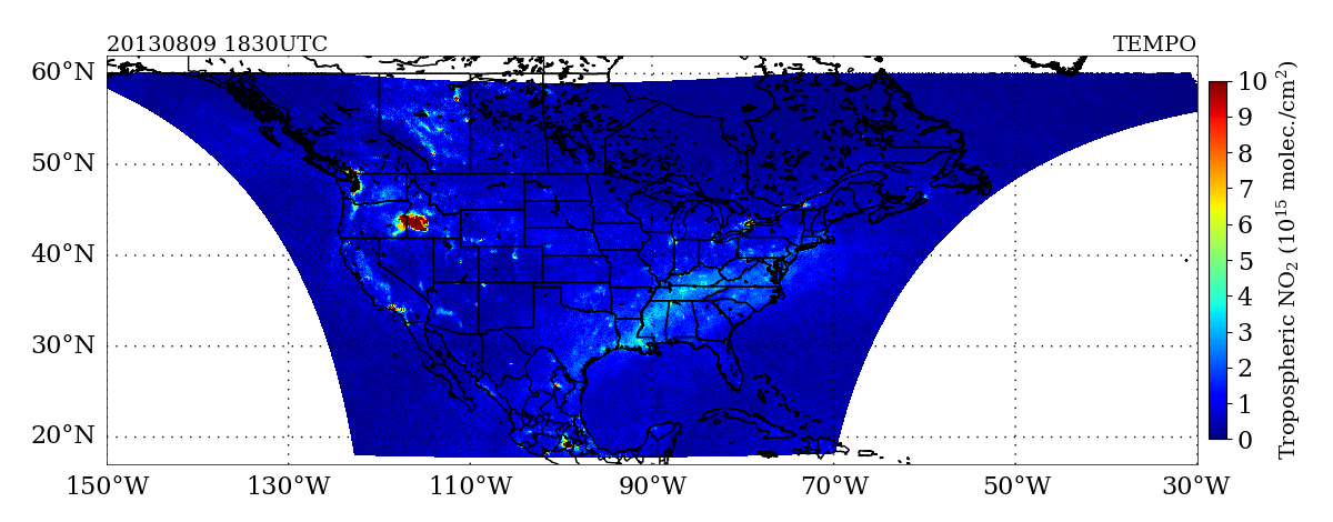
Figure 1. Hourly scan coverage over Tropospheric Emissions: Monitoring Pollution (TEMPO) in the Field Of Regard (FOR). Example of tropospheric NO2 levels from synthetic TEMPO data on 9 August, 2013 (gradients demarcated in different colors). Note there has been a recent shift in the TEMPO FOR to cover Puerto Rico, which has not been updated here. (Synthetic data source code courtesy of C. Chan Miller, Harvard).

Applying TEMPO Data Products in Health and Air Quality Research. The spatiotemporal resolution of TEMPO data products is expected to shift the paradigm of understanding about the impact of air quality upon public health. Trace gases from the Tropospheric Monitoring Instrument (TROPOMI) onboard the Sentinel-5 Precursor polar-orbiting satellite are retrieved at a spatial resolution of 5.5 x 3.5 km2. The increased spatial resolution helps to characterize urban emissions from large cities, which consists of localized sources from transportation corridors, power plants, factories, and others. Methodologies have been developed to apply TROPOMI data to higher spatial resolutions than provided by the operational data product, but the sensor is limited by once daily observations. TEMPO will improve upon the spatial resolution of the operational TROPOMI product while also providing hourly daytime information. TEMPO data will further support air quality and health studies by minimizing cloud interference, and improving our understanding of the complex evolution of pollutants in both large urban areas and rural spaces. Spatial interpolation of TEMPO synthetic data to counties in the state of Alabama (a predominantly rural state) demonstrate higher NO2 concentrations across the more urban areas in Jefferson and Shelby counties (Figure 2). Similar to TROPOMI, methodologies can be developed to layer averaged TEMPO data to selected gridded cells or areas.
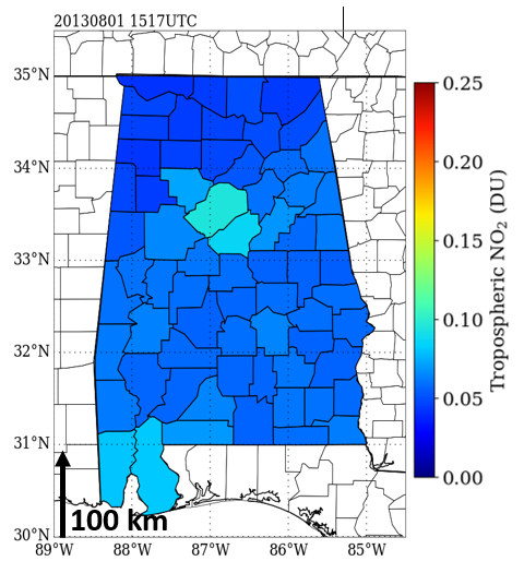
Figure 2. Synthetic tropospheric NO2 (Dobson Units) spatially interpolated to county level throughout Alabama at about 1517 UTC 1 August, 2013. Higher NO2 concentrations are shown in Jefferson and Shelby counties of Birmingham, Alabama.
Acquiring TEMPO Data Products in Air Quality and Health Researc h. TEMPO data products will be available for users in Network Common Data Form (netCDF) files for each of the trace gases along the FOR. In addition, a platform of gridded CSV (comma-separated values) files with vertical column trace gas concentrations, geolocated and with the capability to subset parameters, such as time, region, and pollutant, will be available. The development of platforms using synthetic TEMPO products for multiple user groups is ongoing. Images created using the high-resolution TEMPO synthetic data demonstrate a fine level of detail (Figure 3).
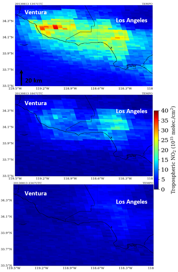
Figure 3. Synthetic TEMPO data showing high-resolution tropospheric NO2 column density on 13 August, 2013 over Los Angeles and Ventura counties in California. The three images show different time frames, including morning (1345 UTC) (top image), midday (1845 UTC) (middle image), and evening (2345 UTC) (bottom image).Promoting Collaborations That Integrate the One Health Concept.
Improving current understanding about the impact of air quality upon global health requires multidisciplinary, collaborative work by environmental and health professionals. A revolutionary constellation of geostationary spectrometers, consisting of the Korean-led Geostationary Environment Monitoring Spectrometer (GEMS), NASA Tropospheric Emissions: Monitoring Pollution (TEMPO), and ESA Sentinel-4, will be capable of monitoring the daytime diurnal evolution of trace gases and chemistry that influence air quality conditions over Asia, North America, and Europe, respectively. Use of data generated by the Sentinel-4, GEMS, and TEMPO instruments to study the impact of air quality changes upon global health will support the One Health concept of improving health by enhancing cooperation and collaboration.
Next story: Epidemiology and Geography. Principles, Methods and Tools of Spatial Analysis. by Marc Souris, Ph.D.